Sequoia & Kings Canyon
Free · no card needed
Sequoia and Kings Canyon are side-by-side national parks in the southern Sierra Nevada where the world's largest trees by volume grow alongside granite canyons, subalpine lakes, and trails that see a fraction of Yosemite's crowds.
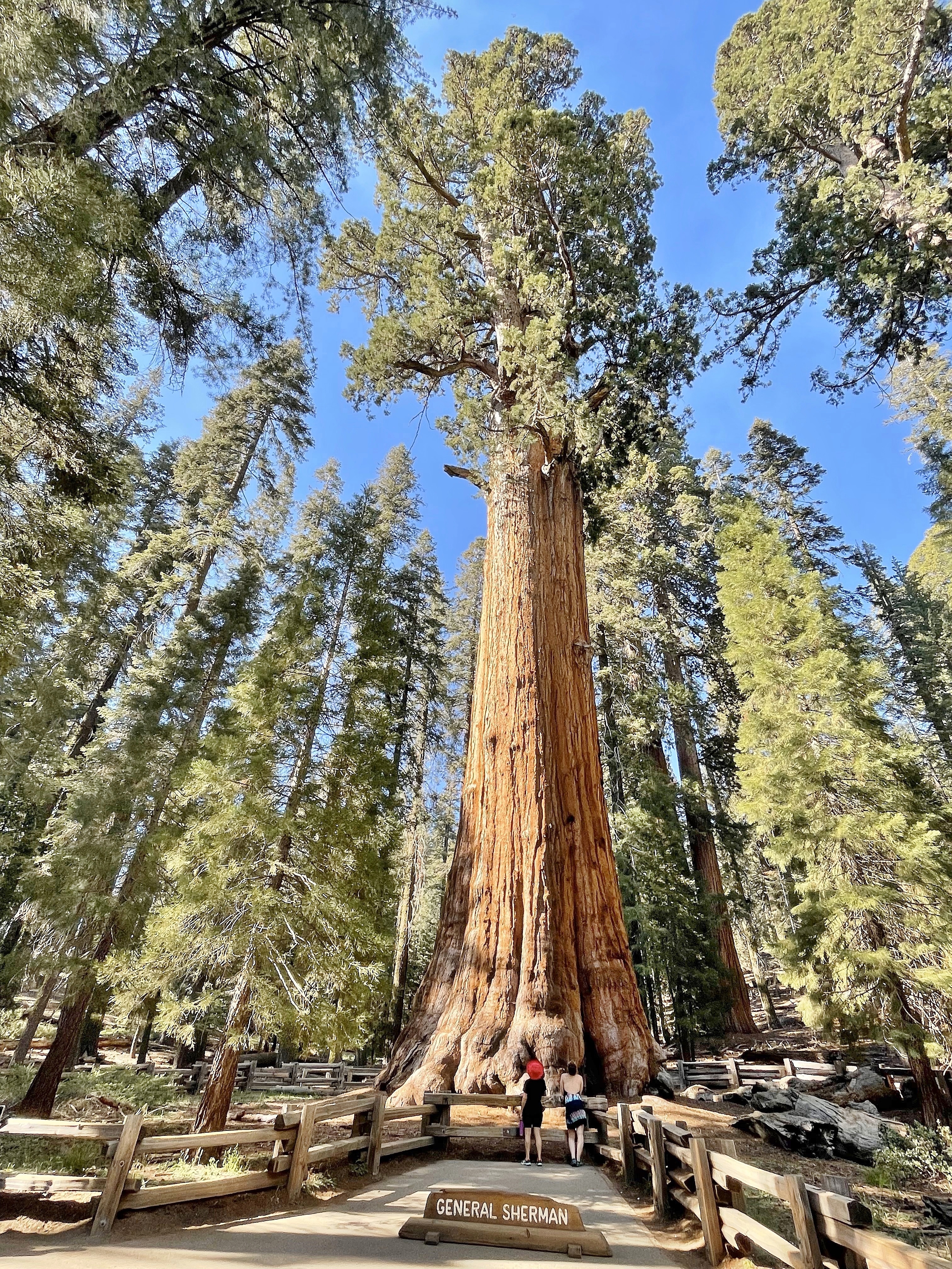
The General Sherman Tree grows in the Giant Forest of Sequoia National Park and is, by volume, the largest living tree on earth: 52,500 cubic feet of red-barked giant, 2,200 years old, and still growing. The numbers are impressive enough. The actual encounter — walking the paved Congress Trail around the sequoia grove, looking up at a dozen trees each larger than anything you've seen, understanding that these organisms have been alive since before the Roman Empire — is one of those experiences that adjusts something in how you understand scale. Yosemite gets all the attention, but the southern Sierra has the trees.
The two parks share an administrative border but have distinct personalities. Sequoia (the southern park) is dominated by the Giant Forest grove and General Sherman, the Moro Rock granite dome with its 360-degree Sierra panorama, and Crescent Meadow where John Muir camped repeatedly. Kings Canyon (the northern park) drops 3,000 feet from the high country into the deepest canyon in the United States — deeper in places than the Grand Canyon — along the South Fork of the Kings River. The Cedar Grove section of Kings Canyon sits at the canyon bottom, ringed by vertical granite walls that dwarf those at Yosemite Valley.
The relative quiet is real and worth building a trip around. On any given summer weekend, Yosemite Valley processes 20,000+ visitors; the Giant Forest and Cedar Grove together see a fraction of that. Lodging exists within the parks — Wuksachi Lodge in Sequoia and Grant Grove Cabins in Kings Canyon — but the parks are not infrastructure-saturated. Trails go deep into the wilderness quickly, and a two-hour walk from any trailhead yields conditions that feel genuinely remote.
The parks are connected by a single road (Kings Canyon Scenic Byway / Highway 180) that is one of the most spectacular drives in California: it descends from Grant Grove through wild river canyon to Cedar Grove, with sheer granite walls rising on both sides. The road closes beyond Cedar Grove in winter and can be snowbound at higher elevations into May. Cell service is effectively zero inside the parks; download offline maps and permit reservations before arrival.
The practical bits.
- Best time
-
May – June · September – OctoberLate May and June give accessible roads, snowmelt waterfalls, and opening wildflower meadows. September and October are cooler, less crowded, and have the best light for photography. July and August are peak season but manageable since these parks are less visited than Yosemite. Winter closes most of Kings Canyon and higher Sequoia roads; snow chains or 4WD required.
- How long
-
4 nights recommendedTwo nights covers General Sherman and Moro Rock. Four nights adds Cedar Grove, backcountry trails, and a proper alpine lake hike. Seven nights approaches a full wilderness circuit of both parks.
- Budget
-
~$160 / day typicalPark entry is $35/vehicle (valid 7 days for both parks). Wuksachi Lodge runs $200–350/night in peak season. Budget travelers camp (Lodgepole and Azalea campgrounds) for $30–35/night. Food options inside parks are limited; stock up in Three Rivers (Sequoia gate) or Fresno.
- Getting around
-
Personal vehicle essentialNo public transit reaches these parks. A rental car from Fresno (1h from Sequoia entrance) is the standard approach. The Sequoia Shuttle runs between Visalia and Lodgepole in summer (check nps.gov for current schedule). Within the parks, roads are two-lane mountain roads; RVs over 22 feet are restricted on some routes. Waze/Google Maps works at park entrances; download NPS maps for interior navigation.
- Currency
-
US Dollar ($)Cards accepted at park lodges and most camp stores. Cell service is unreliable to nonexistent inside parks. Download everything before entering — NPS app, maps, permit confirmations.
- Language
- English. Park staff are multilingual in major visitor centers. Most visitor brochures available in Spanish.
- Visa
- Standard US entry requirements apply. ESTA for most European, Australian, and select other nationalities. Visa required for many other countries.
- Safety
- Wildlife awareness required — black bears are present and food storage lockers mandatory at campgrounds. Mountain lion presence is low-risk with standard protocols. Flash floods possible in Canyon bottom in summer storms. Winter roads require chains; check Caltrans road conditions before driving.
- Plug
- Type A / B · 120V — voltage converters needed for European/Asian devices.
- Timezone
- PST · UTC-8 (PDT UTC-7 March – November)
A few specific picks.
Hand-picked, not algorithmic. Each of these has earned its space.
The largest living tree on earth by volume — 52,500 cubic feet, 274 feet tall, estimated 2,200 years old. Walk the Congress Trail for a 2-mile loop through the densest concentration of giant sequoias in the world.
A granite dome rising above the Giant Forest. A 350-step trail climbs to the summit for 360-degree views of the Great Western Divide, Castle Rocks, and the San Joaquin Valley. Best at sunrise or golden hour before the afternoon haze builds.
The valley floor at the bottom of the deepest canyon in the US. Sheer granite walls rise 5,000 feet from the Kings River. Zumwalt Meadow trail is a 1.5-mile flat loop past sculpted granite buttresses and river pools. Minimal crowds.
Highway 180 descends 3,000 feet through wild river canyon from Grant Grove to Cedar Grove — one of California's most dramatic drives. No side-road pullouts for large vehicles; just concentrated canyon walls and the river alongside.
John Muir's 'gem of the Sierra' — a subalpine meadow ringed by sequoias and accessible by a paved spur road. The Log Meadow loop and Tharp's Log (a pioneer homestead inside a fallen sequoia) extend the visit.
A modest but well-designed museum explaining giant sequoia ecology, fire cycles, and how the NPS fire-suppression policies of the early 20th century nearly prevented sequoia regeneration. Essential context before walking the grove.
A 41-mile overnight loop through granite passes and glacial lakes — one of the best multi-day hikes in the Sierra Nevada. Requires wilderness permits (reservable through recreation.gov). Best July through September.
A fallen sequoia log with a tunnel cut through it in 1938. Cars drive through. Sounds gimmicky; seeing the scale of a sequoia's cross-section from a car window is genuinely clarifying.
A 40-foot waterfall in the canyon accessible by a short flat walk from a roadside pullout. Snowmelt-fed and at maximum flow in May–June. One of the easiest big waterfall views in either park.
A strenuous 13-mile round-trip to 11,204 feet, gaining views of the entire High Sierra from the Great Western Divide. A serious day hike requiring acclimatization. The best summit in Sequoia for those prepared for it.
Pick a neighborhood, not a hotel.
Sequoia & Kings Canyon is a city of neighborhoods. The one you stay in shapes the trip more than the property does.
Different trips for different travelers.
Same city, very different stays. Pick the lens that matches your trip.
Sequoia & Kings Canyon for first-time national park visitors
Sequoia and Kings Canyon provide the singular giant tree experience without Yosemite's planning complexity. Three nights is the right entry point. Congress Trail and Moro Rock are accessible, impressive, and manageable.
Sequoia & Kings Canyon for families with children
The Junior Ranger program, Tunnel Log, General Sherman accessibility, and Cedar Grove river swimming all work well with children. Book Wuksachi Lodge or Lodgepole campground well ahead for July and August visits.
Sequoia & Kings Canyon for serious hikers and backpackers
The Rae Lakes Loop, High Sierra Trail to Mount Whitney, and the Mineral King alpine routes are among the best backcountry hiking in the United States. Permits for popular routes require early planning (recreation.gov, late February release).
Sequoia & Kings Canyon for yosemite alternative seekers
If you want Sierra Nevada granite, giant trees, and mountain meadows without the Yosemite Valley reservation complexity and tram crowds, Sequoia and Kings Canyon are the direct answer.
Sequoia & Kings Canyon for photographers
The scale challenge of sequoias (they're too large for standard wide angles to convey), Moro Rock dawn light, Kings Canyon golden-hour canyon walls, and Zumwalt Meadow reflections are all technically interesting problems.
Sequoia & Kings Canyon for winter visitors
Snowshoeing and cross-country skiing in the Giant Forest in winter, with the sequoias snow-loaded, is one of the most unusual winter recreation experiences in California. The Generals Highway stays open except during active storms; most other park roads close.
When to go to Sequoia & Kings Canyon.
A quick year at a glance. Great, good, or skip — see what each month is doing before you book.
Most roads closed. Giant Forest snowshoe trails open. Very few visitors. Atmospheric and silent.
Similar to January. Cross-country ski touring possible from Wuksachi Lodge. Cedar Grove closed.
Transition month. Chains still may be required. Not reliable for planning.
Kings Canyon Scenic Byway often reopens mid-April. Waterfalls building from snowmelt. Crowds low.
Roaring River Falls and Mist Falls at peak flow. Wildflowers in lower meadows. Excellent hiking conditions.
Best balance of conditions and crowds. Cedar Grove accessible, Kings River high. Pre-peak prices.
Busiest month. Book Wuksachi Lodge and campgrounds well ahead. Afternoon thunderstorms possible at elevation.
High season continues. Cedar Grove swimming holes warm. Wildfire smoke possible in hot years.
Crowds falling sharply post-Labor Day. Aspen color in higher valleys. Excellent all-conditions hiking.
Cedar Grove closes in late October. Autumn colour at mid-elevations. Best photography month.
Most Cedar Grove infrastructure closed. Chains may be needed. Very quiet — solitude guaranteed.
Snow on sequoias — extraordinary visual. Chains required. Most facilities closed except Giant Forest area.
Day trips from Sequoia & Kings Canyon.
When you want a change of pace. Each one's a half-day or full-day out, easy from Sequoia & Kings Canyon.
Mineral King Valley
1 h 30 minA narrow, winding 25-mile access road (25 mph maximum, no RVs) leads to a high alpine valley at 7,800 feet with access to multiple 11,000+ foot peaks. Marmots are notorious for chewing car radiator hoses — wrap exposed car parts in hardware cloth if you park overnight.
Hume Lake
45 minA reservoir in Sequoia National Forest between Grant Grove and the Big Stump entrance. Excellent summer swimming, canoe and kayak rentals, and a Christian camp with a public beach access. Not technically in the national park but on the standard route.
Fresno
1 hThe nearest city to both parks. Stock food and supplies before entering the park — inside options are limited and expensive. Fresno has good grocery stores, a Target, and an REI for any missed gear.
Three Rivers
15 minThe small town just below the Sequoia entrance has restaurants, grocery stores, and river swimming access in the Kaweah River's south fork. Several B&Bs and motels provide alternative park-adjacent accommodation.
Kings River Rafting
1 h 30 minThe Kings River below the canyon (outside the park boundary) is one of the best whitewater rivers in California in the spring. Several Fresno-based outfitters run full-day Class III–IV trips in April through June when snowmelt is high.
Giant Sequoia National Monument
VariableThe Converse Basin grove and other sequoia stands within the National Monument south of Grant Grove (administered by the US Forest Service, not NPS) have old-growth giant sequoias without the park entry fee or the National Park visitor volumes.
Sequoia & Kings Canyon vs elsewhere.
Quick honest reads on the cities people compare Sequoia & Kings Canyon to.
Yosemite Valley has El Capitan, Half Dome, and the most iconic granite scenery in North America. Sequoia and Kings Canyon have the world's largest trees and a deeper canyon with a fraction of the crowds. Both are Sierra Nevada parks; the choice depends on whether your priority is famous granite walls or ancient trees.
Pick Sequoia & Kings Canyon if: You want giant sequoias, a deeper canyon than Yosemite's, and a quieter Sierra Nevada experience.
Redwood National Park has the world's tallest trees (coastal redwoods) in a fog-belt rainforest setting on the Northern California coast. Sequoia has the world's largest trees in a Sierra Nevada mountain setting. Completely different landscapes and moods.
Pick Sequoia & Kings Canyon if: You want the mountain Sierra setting and the volume-record giant sequoias rather than the rainforest coastal experience.
The Grand Canyon is wider, more famous, and has helicopter tour infrastructure. Kings Canyon is deeper in some sections, has live river access at the bottom, and attracts a fraction of the Grand Canyon's traffic. The granite canyon walls versus sandstone layering make them visually distinct.
Pick Sequoia & Kings Canyon if: You want a granite canyon with river access at the bottom, fewer crowds, and giant trees nearby.
Death Valley is desert extremes — lowest elevation in North America, hottest temperatures, abstract geological color. Sequoia and Kings Canyon are mountain extremes — largest trees, deep granite canyon, alpine lakes. Both are California parks but entirely different ecosystems and experiences.
Pick Sequoia & Kings Canyon if: You want forest, tree scale, and mountain hiking rather than desert geology and extreme heat.
Itineraries you can start from.
Real plans built by Roamee. Use one as your starting point and change anything.
Night one and two at Wuksachi Lodge: General Sherman, Congress Trail, Moro Rock, Crescent Meadow. Night three: drive Kings Canyon Scenic Byway to Cedar Grove, Zumwalt Meadow walk, Roaring River Falls. Return via Fresno.
Two nights Giant Forest (sequoia grove, Moro Rock, Alta Peak for fit hikers). Two nights Cedar Grove (Kings Canyon canyon walks, Road's End to Mist Falls hike). Final night Grant Grove en route out.
Two nights lodging at park entry. Five nights on Rae Lakes Loop backcountry permit (Kings Canyon wilderness). Requires solid hiking fitness and wilderness permit reservation. Freshly filtered water and bear canisters required.
Things people ask about Sequoia & Kings Canyon.
What is the difference between Sequoia and Kings Canyon National Parks?
They're side-by-side and jointly administered but have distinct landscapes. Sequoia (southern park) is defined by the Giant Forest of giant sequoias, including General Sherman, and the Moro Rock granite dome. Kings Canyon (northern park) features the General Grant Tree grove and, more dramatically, the Cedar Grove canyon — the deepest canyon in the US, with granite walls rising 5,000 feet from the Kings River. A single park entry fee ($35) covers both.
How do Sequoia and Kings Canyon compare to Yosemite?
Yosemite Valley is more famous and has the iconic walls of El Capitan and Half Dome; it also processes vastly more visitors. Sequoia and Kings Canyon are less visited, have no valley tram system, and offer a more remote feel even in peak season. The sequoia groves — with trees far larger in volume than any in Yosemite — are the singular experience here. Kings Canyon's canyon depth exceeds the Grand Canyon's in some sections. For a comparable Sierra trip without the Yosemite crowds, these parks are the answer.
What is the General Sherman Tree?
General Sherman is the largest single-stem tree on earth by volume — 52,500 cubic feet of living wood. It stands 274.9 feet tall, has a base circumference of 102.6 feet, and is estimated at 2,200 years old. Volume is the measure used because several taller or wider trees exist; Sherman wins on total living mass. It is accessed by a paved 0.5-mile path from the parking area on Wolverton Road, or by the Congress Trail loop (2 miles) that passes 14 additional named sequoias.
When is the best time to visit?
Late May through June is ideal: roads are opening from winter, snowmelt waterfalls are at peak flow, wildflowers appear in the meadows, and crowds are below midsummer levels. September and October bring golden light, cool temperatures, and post-summer quiet. July and August are busy but manageable compared to Yosemite. Winter (November–April) closes most of Kings Canyon and requires chains on Sequoia roads — a very different, very quiet experience for prepared visitors.
Do I need a car to visit Sequoia and Kings Canyon?
Effectively yes. No direct public transit reaches either park. The Sequoia Shuttle (Visalia to Giant Forest) operates in summer and provides basic connectivity for those arriving by Greyhound or Amtrak to Visalia — but it runs limited hours and doesn't reach Kings Canyon. Renting a car from Fresno (1 hour to the Sequoia entrance) is the standard approach.
What is Moro Rock?
Moro Rock is a solitary granite dome rising from the Giant Forest plateau to 6,725 feet. A paved staircase with 350 steps climbs its north face to a railed summit platform with panoramic views — the Great Western Divide to the east, the foothills and San Joaquin Valley to the west, and sequoia-covered ridges in all directions. The hike takes 20–30 minutes and is accessible to most fit visitors. The road to Moro Rock is closed to vehicles and open only to shuttle and bicycle November through May.
What are giant sequoias and why are they here?
Giant sequoias (Sequoiadendron giganteum) grow naturally only in 77 groves on the western slopes of the Sierra Nevada, at elevations between 5,000 and 7,000 feet. They are the world's largest trees by volume and can live 3,000+ years. They require specific conditions: deep snowpack for moisture, and periodic fire to open their seed cones and clear competing vegetation. Fire suppression throughout the 20th century suppressed sequoia regeneration; the NPS now uses controlled burns and allows some natural fires to burn in sequoia habitat.
How deep is Kings Canyon?
The canyon created by the South Fork Kings River reaches depths of approximately 8,200 feet from the Monarch Divide peaks to the canyon floor at Road's End — making it one of the deepest canyons in North America, deeper than the Grand Canyon's mile-deep (5,280 foot) measurement from the canyon rim. The Cedar Grove section, accessible by Highway 180, sits at the canyon bottom where the Kings River runs between sheer granite walls. The scale becomes clear standing in Zumwalt Meadow looking straight up.
Is bear safety a concern?
Yes — black bears are present throughout both parks. Food storage is mandatory: all food, scented items, and toiletries must go in provided bear boxes at campgrounds and parking areas, or in a rented bear canister for backcountry. Never leave food in a car (bears break windows). Bears in these parks are habituated to human presence but are not aggressive; they want calories, not confrontation. Follow NPS guidelines and the encounters are low-risk.
What should I know about permits for hiking?
Day hiking requires no permit. Wilderness overnight permits are required for all backcountry camping, including the Rae Lakes Loop and any High Sierra Trail overnight. Permits are reserved through recreation.gov beginning in late February for the following summer season; popular routes (Rae Lakes, High Sierra Trail) sell out within minutes of going live. Walk-up permits for remaining quota are available at ranger stations. Check nps.gov/seki for current permit rules.
What is the Kings Canyon Scenic Byway?
Highway 180 west of Grant Grove descends through Sequoia National Forest and into the canyon, reaching Cedar Grove at the bottom — a drop of roughly 3,000 feet in 35 miles. This stretch, within the national monument and park, is one of the most dramatic mountain drives in California: granite walls close in, the river runs alongside, and the scale of the canyon becomes progressively more apparent. The road beyond Cedar Grove (Road's End) is paved but closes in winter and is inaccessible by RVs over 22 feet.
Where do I stay in Sequoia and Kings Canyon?
Wuksachi Lodge (Sequoia, near Giant Forest) is the only full-service hotel inside the park — 102 rooms, restaurant, the most comfortable option, around $200–350/night in season. Grant Grove Cabins (Kings Canyon) are more rustic and cheaper. Cedar Grove Lodge (Kings Canyon) is a small motel-style property open only in summer. Campgrounds at Lodgepole, Azalea, and Moraine (reservations via recreation.gov) are $30–35/night. Lodges in Three Rivers (outside Sequoia gate) provide more options at lower cost.
Can I drive through the sequoia grove?
Some roads pass through the grove but the main sequoia experience is on foot. The Generals Highway through Giant Forest passes near multiple giant trees. The Tunnel Log road feature lets cars drive through a fallen sequoia. The Congress Trail (2 miles, fully paved) is the best sequoia walk. Vehicles over 22 feet are restricted from the Wuksachi-Moro Rock road. Many visitors take the park shuttle to avoid parking challenges at the General Sherman trailhead.
What is the best hike for a first-time visitor?
The Congress Trail (2 miles, 400 feet elevation gain) is the classic choice — it passes General Sherman and more than a dozen named sequoias in the densest old-growth grove in both parks. For views, the Moro Rock stairs (0.5 mile, 300 feet) are the quickest panorama. For Cedar Grove, Zumwalt Meadow loop (1.5 miles, flat) gives canyon grandeur without effort. Mist Falls trail (8 miles round trip, moderate) from Road's End is the best Kings Canyon day hike for fit hikers.
Is cell service available in the parks?
No — cell service is effectively zero inside both parks beyond the Highway 99 corridor near the western entrances. Download NPS offline maps, your permit confirmation, accommodation details, and any relevant information before entering the parks. The NPS app (visit the Sequoia and Kings Canyon pages) has downloadable offline maps. Lodgepole Visitor Center and Wuksachi Lodge have paid wifi.
What is the difference between a giant sequoia and a coastal redwood?
Giant sequoias (Sequoiadendron giganteum) grow only on the Sierra Nevada's western slopes and are the world's largest trees by volume and mass. Coastal redwoods (Sequoia sempervirens) grow along California and Oregon's foggy coast and are the world's tallest trees — reaching over 380 feet versus the sequoia's 310 feet. Redwoods are taller and more slender; sequoias are shorter but massively wider at the base. Both are extraordinary. Muir Woods near San Francisco and Redwood National Park are the best coastal redwood destinations.
Are Sequoia and Kings Canyon good for families?
Excellent for families. The Congress Trail and General Sherman are accessible to children of any age. Tunnel Log is a child favorite. Moro Rock stairs work for children 6+. Cedar Grove's river access has shallow swimming holes in summer. Junior Ranger programs at all visitor centers engage children actively with ecology and history. Book campgrounds or Wuksachi Lodge well ahead in July–August — summer weekends fill months in advance.
How long is the drive from Los Angeles or San Francisco?
From Los Angeles, the Sequoia entrance at Ash Mountain (near Three Rivers) is approximately 220 miles, a 4-hour drive via Highway 99 and Highway 198. From San Francisco, it's approximately 280 miles via Highway 99 to Fresno then Highway 180 to the Big Stump (Kings Canyon) entrance, taking about 4.5 hours. Both parks are viable self-drive road trips from either California city, typically done as part of a longer national park circuit.
Your Sequoia & Kings Canyon trip,
before you fill out a form.
Tell Roamee your vibe — get a real plan, swap whatever doesn't feel like you.
Free · no card needed