You've Saved 40 TikToks About Iceland. You Still Don't Have an Itinerary.
Forty-seven browser tabs. A Notion doc titled "ICELAND v3 FINAL." Three Reddit threads from 2021. A TikTok folder called "iceland maybe" with 62 saves.
And a group chat that just pinged: so are we booking flights or what.
You don't have an answer. Not because you lack ideas — you have too many. You have a glacier lagoon, a hot river, a black-sand cove, an abandoned plane wreck, and a turf-roof hamlet, and no idea which of these Iceland Ring Road hidden stops are 12 minutes off Route 1 and which are a 6-hour gravel commitment.
The inspiration is solved. The route is not.
That gap — between camera roll and calendar — is the actual Iceland planning problem. And it's not yours alone.
Why Don't the Best Iceland Ring Road Hidden Stops Show Up on Google Maps?
Google Maps surfaces what's tagged, reviewed, and SEO-optimized — Blue Lagoon, Skógafoss, Reynisfjara. The Iceland Ring Road hidden stops worth driving for behave differently: unmarked gravel turnoffs, F-road numbers buried in Reddit replies, farm-stay pins dropped in DMs because the host doesn't want a queue. A map app weights pins by review count, which is the exact metric the good stuff doesn't have.
The Ring Road — Route 1 — is a 1,332 km loop around Iceland. Pure driving time is about 17 hours. Anyone who's actually done it will tell you to budget 7 to 10 days, and that's before you start adding the stops that make the trip worth taking.
Google Maps will route you around it. It will not tell you what to stop for.
A glacier lagoon and a gas station are equal pins to a map app. They are not equal stops on a 7-day loop.
So travelers do one of two things. They over-index on the tourist track and come home with the same 40 photos everyone else has. Or they miss the good stops by 2 kilometers and never know they were there.
Neither is a planning problem. Both are a translation problem.
Why Do Current Planning Tools Break for Iceland?
The tools you're using right now weren't built to route the unmapped. Google Maps treats every pin as equivalent geometry, Reddit gives you threads instead of itineraries, and TikTok gives you vibes without coordinates — so stitching them together by hand becomes the work, not the vacation.
Google Maps has no concept of worth a detour. A 90-minute side trip to Stuðlagil canyon and a 90-minute side trip to a Bónus grocery store look identical to the routing engine.
Reddit's r/VisitingIceland is gold. It's also four-year-old threads with conflicting advice, mods who deleted the best comments, and a top reply that says "depends on the season" with no further detail.
TikTok saves give you visual proof a place exists. They give you almost no geographic metadata. You can't route a vibe.
Travel blogs are SEO-optimized for the same 15 stops. The 16th through 40th stops — the ones you actually want — are buried in comments sections nobody crawls.
And then there's the planner's last resort: a spreadsheet or a Notion doc. Day 1, Day 2, Day 3. A column for "maybe?" that grows faster than the column for "yes." This is where trips go to die.
The playbook is broken because every tool in it was built for a different problem. Google Maps was built to route between places it already knows. Reddit was built for threads, not itineraries. TikTok was built for attention, not coordinates.
That's not a tooling preference. It's a category error.
How Did Travel Discovery Move to TikTok and Reddit — and Leave Planning Behind?
Discovery migrated to social feeds in the last five years while the planning surface stayed stuck in 2015. More than 60% of Gen Z and younger millennials now scout travel on TikTok before they ever open a search bar, and Reddit became the trust layer where "what's it actually like" beats "top 10 lists" every time.
The inspiration surface moved. The planning surface didn't.
Result: the discovery-to-itinerary gap widened. More saves than ever. The same broken planning tools at the end of the funnel.
This hits urban professionals planning bucket-list trips the hardest. You're 28 to 36, you have four friends, two of you are senior enough to actually take the time off, and the group chat is a graveyard of dropped links nobody's geocoded.
The trip doesn't fail because nobody wants to go. It fails because nobody can produce a route the rest of the group will rally behind.
The 2010s travel playbook was: search, blog, list, book. The 2020s playbook is: scroll, save, share, panic. The middle step — turning the scroll into a route — is the part no one shipped a tool for.
Until recently.
Can AI Travel Planners Actually Find Iceland's Hidden Gems?
Yes — because AI reads the layer Google Maps ignores. Reddit threads, TikTok captions, blog comments — the unstructured commentary where actual local knowledge lives. A stop that surfaces in 8 separate Reddit threads, gets photographed on TikTok, and sits 14 km from Route 1 is probably real; a stop mentioned once in a 2019 blog with no coordinates is probably not.
Signal versus noise. That's the move.
The second move is drive-time triage. A 10-minute detour and a 4-hour detour are different categories of decision on a 7-day loop. Most planners treat them the same. AI tools that understand routing don't.
The third move — the one that actually saves you — is sequencing. Knowing about Reykjadalur, Stuðlagil, and Rauðasandur is the easy part. Knowing that you should hit Reykjadalur on Day 1 (it's near Reykjavík), Stuðlagil on Day 4 (it's east), and Rauðasandur on Day 6 (Westfjords) — that's the part the spreadsheet can't do for you in under three hours.
The diagnosis dictates the treatment. The problem was never finding hidden Iceland stops. The problem was sequencing them into a loop you could actually drive. AI tools that ingest social saves and output ordered routes are pointed exactly at that gap.
Not all of them are good yet. The ones that work understand that itineraries are constraint problems, not inspiration problems.
Where Roamee Fits
We've been thinking about this gap a lot. Roamee have been arguing for years that AI travel planning is the next planning category — lets you drop saved TikToks, Reddit links, and screenshots straight into a trip, then extracts the actual stops, geocodes them, and stitches them into a drivable Ring Road loop with realistic daily timing. The goal isn't to replace your camera roll — it's to read it. If you've already done the discovery on TikTok, AI itinerary generation shouldn't take another six weekends.
How Do You Turn 40 Saved TikToks Into a Drivable 7-Day Loop?
Here's what the workflow looks like when the translation layer works: dump every save into one inbox, let AI extract the real stops, propose a counterclockwise loop, cap each day at four hours of driving, and send one link to the group chat.
Step 1: Dump everything into one place. 40+ TikToks. The 6 Reddit threads you bookmarked. Your friend's Google Doc from her 2023 trip. The screenshot of a tweet you can't find again. One trip, one inbox.
Step 2: Extract the real stops. AI parses the captions, comments, and metadata. From a typical Iceland inbox you'll get a list that looks something like this:
- Reykjadalur hot river — 45 min hike, geothermal stream you bathe in
- Stuðlagil canyon — basalt columns, eastern Iceland, 20 min off Route 1
- Djúpalónssandur — black pebble beach on Snæfellsnes
- Vestrahorn — the mountain everyone's drone footage starts with
- Hvítserkur — sea stack on the north coast, 15 min detour
- Rauðasandur — red-sand beach in the Westfjords, a half-day commitment
- Stokksnes — private land, small fee, the iconic black-sand reflection shot
- An unmarked geothermal pool in the Westfjords — Reddit-only, no signage
Eight stops, none of which are on the average top-10 list.
Step 3: Propose the loop. Counterclockwise is the call. South coast first — front-loads the marquee waterfalls and Vestrahorn. Westfjords saved for days 5–6, when you've adjusted to the driving and earned the gravel.
Step 4: Cap the daily drive. Under 4 hours of driving per day. Hidden stops slotted between the famous ones, not bolted on top of them. The day with Stokksnes and Vestrahorn doesn't also try to include Stuðlagil — that's how trips become endurance events.
Step 5: One link to the group chat. Flights get booked the same evening. The Notion doc gets archived without ceremony.
The whole thing takes an afternoon instead of a month.
The Future of Travel Planning Looks Like Your Camera Roll
The next decade of trip planning is going to start from saves, not searches.
The valuable layer was never the top-10 list. It was the connective tissue between scattered inspiration and ground truth — the part that nobody built because building it required reading the social web at scale.
The guidebook is being rewritten by Reddit commenters and regional TikTok creators. Local knowledge is finally legible to machines, which means it's finally routable.
This isn't unique to Iceland. The same pattern shows up in Japan, in Patagonia, in the American Southwest — anywhere the best stops are tribal knowledge instead of TripAdvisor rankings.
The tool you'll use in 2030 won't ask you what kind of trip you want. It'll ask to see what you've already saved.
The Real Iceland Trip Is Off Route 1
The difference between a good Iceland trip and a memorable one is roughly 8 stops nobody Googled.
They're not secret. They're just unindexed. Reykjadalur is in dozens of TikToks. Rauðasandur has its own subreddit corner. Stokksnes is shot from the same three angles by every drone owner in Reykjavík.
The planning bottleneck was never inspiration. It was translation.
If your camera roll already knows what trip you want to take, the tool should too. The rest is just routing.
Iceland Ring Road Hidden Stops: FAQ
What is the Iceland Ring Road and how long does it take to drive?
The Ring Road is Route 1, a 1,332 km loop that circles Iceland. Pure driving time is about 17 hours, but that number is misleading. Realistically, 7 days is the minimum to drive it meaningfully, and 10 days is ideal if you want to include hidden stops, gravel detours, and the Westfjords without rushing.
Should I drive the Ring Road clockwise or counterclockwise?
Counterclockwise — south coast first — is the most common call and the one I'd default to. It front-loads the marquee waterfalls and glacier lagoons while you're still fresh, and clusters the off-map detours into days 4 through 6 when you've found your rhythm. Clockwise works if you specifically want to hit the Westfjords early with full energy, but it puts the famous stuff at the end when you may be road-tired.
What are the most underrated hidden stops along Route 1?
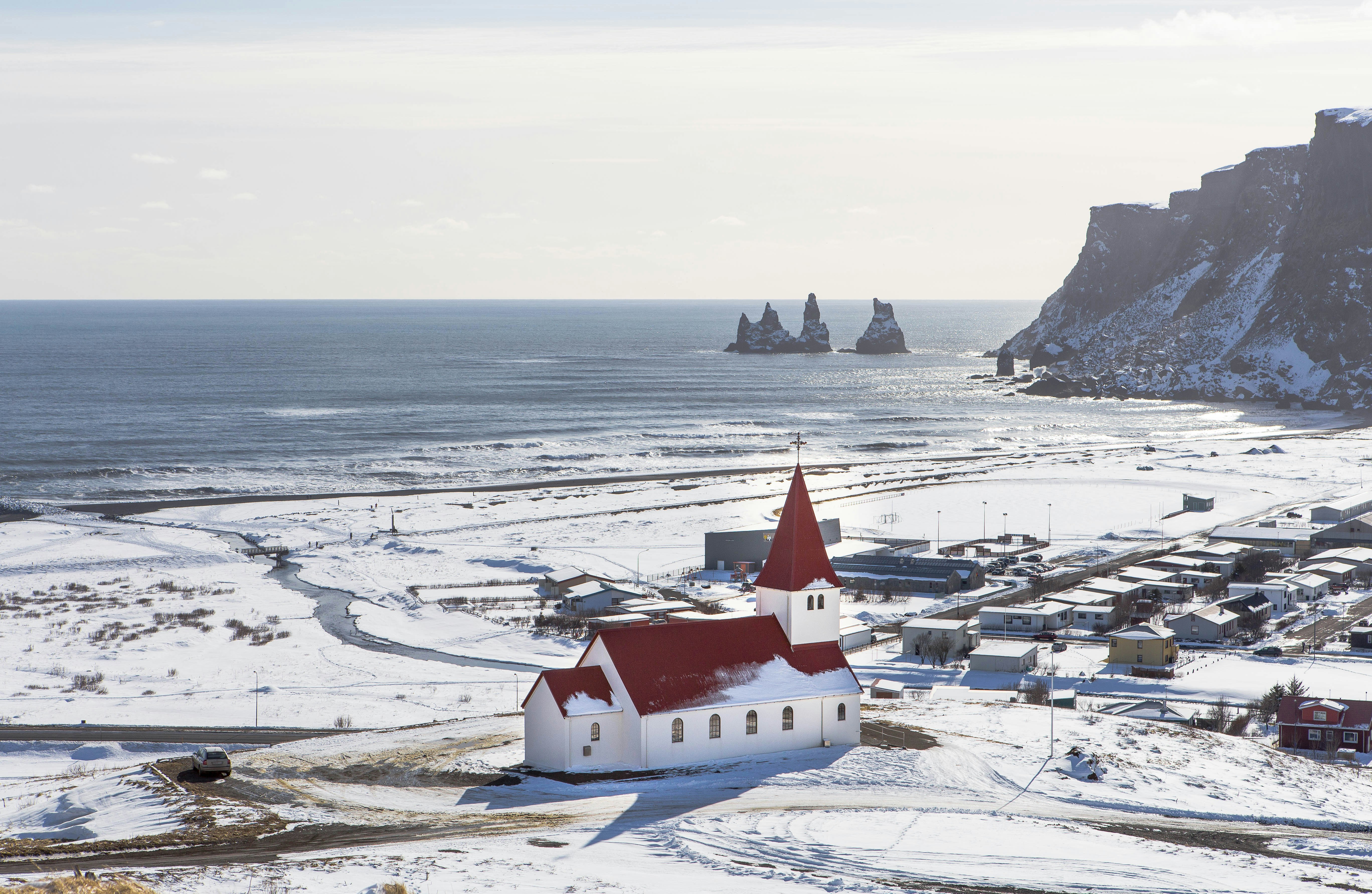
The ones that consistently show up across Reddit and TikTok but rarely on top-10 lists: Reykjadalur (geothermal river you bathe in), Stuðlagil canyon (basalt columns, east Iceland), Rauðasandur (red-sand beach in the Westfjords), Stokksnes (Vestrahorn reflection shot, private land, small fee), Hvítserkur (sea stack on the north coast), Djúpalónssandur (black pebble beach on Snæfellsnes), and an unmarked geothermal pool in the Westfjords that locals share via DM. Reykjadalur, Hvítserkur, and Stokksnes are short detours, while Rauðasandur and the Westfjords pools are half-day commitments.
When is the best time of year to visit Iceland's hidden stops?
June through August is the full-access window — midnight sun, all F-roads open, every Westfjords detour reachable. September is the shoulder-season sweet spot: northern lights return, crowds thin out, and most hidden stops are still drivable. Winter narrows the trip significantly — many off-map stops become unreachable, and a smart winter plan sticks to the south coast.
How do I turn 40+ saved TikToks into an actual Iceland itinerary?
Two paths. Manual means extracting location names from each save, geocoding them one by one, sorting by Ring Road position, then figuring out drive times — slow, error-prone, and where most trips stall. AI means tools that ingest social saves directly, extract the stops, and stitch them into a drivable loop with realistic daily timing. Either way, the bottleneck is geocoding and sequencing, not finding stops — you already have plenty of stops.
Can AI itinerary tools really find stops from Reddit and TikTok?
Yes, and this is where they pull ahead of map apps. Modern tools parse unstructured social content and cross-reference it against geographic context, which is exactly what Google Maps doesn't do. They surface stops mentioned repeatedly across sources — that repetition is the signal-versus-noise filter. The right way to use them is as the starting layer over Google Maps, not a replacement.
What should I book in advance near these off-grid locations?
Farm stays and guesthouses in the east and Westfjords go first — inventory is tiny and the good ones sell out 3+ months ahead. A 4x4 rental is non-negotiable if any F-roads or the Westfjords are on the route. And any paid-access stop with limited capacity — Stokksnes (private land, small fee), glacier hikes, and ice caves — should be booked weeks ahead, not days.